Engineer on the Grantham Canal
Map maker
Redmile connection
Agent to the Duke of Rutland
under construction

|
Engineer on the Grantham Canal under construction |
|
Engineer to the Grantham canal
The 4th Duke of Rutland died in 1787 but his Agent, William King, exerted a notable influence during the minority of John, 5th Duke of Rutland, until 1801 and actively encouraged efforts towards the realisation of the Grantham to Nottingham canal. This was fortunate for without his support it is doubtful if the canal would have been built at all.
King was an intelligent and forward looking estate manager. He was however suspicious of industrialisation and of the effects that this was having on the erstwhile peasantry in towns such as Nottingham. His prime interest in the canal was in the opportunities it would bring to the Belvoir farms and to the agricultural community as a whole and he did not want 'stockingers or manufacturers' established in its wake and took care to see that there were none within the bounds of his jurisdiction. With his help support was canvassed amongst a wide section of the local population including the local aristocracy, farmers, clergy and traders. Money was subscribed for a survey and William Jessop, a noted canal engineer who had been consulted over the initial stages of the Nottingham Navigation, was asked for advice on the matter and proposed a canal that would connect with the Trent at Radcliffe. He estimated the cost at £58,000.
Opposition to the canal came from the river Witham Commissioners and the traders of Newark fearful of losing water and trade respectively. Undismayed by the check, King and his colleagues set out to placate the opposition and planned the introduction of a new bill in the following year. In the new bill they proposed stringent regulations over the amount of water to be taken from Denton Brook (the only tributary of the Witham to be used as a water supply) allowed a few influential landowners privileged carriage of their goods on the canal and made provision for a junction at Stenwith Bridge for a canal that, it was proposed, would be built from Newark. This latter project in fact came to nothing, but the inclusion in the Bill of the clause providing for the junction was an effect sop to the Newark interest. The Main line junction with the Trent was resurveyed and moved to Trent Bridge and the new bill was introduced to Parliament in 1793. It passed the commons on the 8th, the Lords on the 17th and gained assent of George the Third on the 30th of April. Amid scenes of rejoicing in the town the canal was born.
It must be remembered that civil engineering was at this time still in its infancy. Even Jessop, an acknowledged master of canal construction could make serious mistakes and although Green had some experience of this type of work, involvement in such a project was new to King. It was not long before the project ran into problems. A surveyor named Hodgkinson was employed to lay the line from Grantham to Cropwell Butler, but his work was deemed to be unsatisfactory and after reporting that deep cuts would be needed at Harlaxton he was fired in the Autumn of 1793.
A second Act allowed shares of £120 to be sold and compelled the payment of two extra £10 calls on the original issue. It also removed the 8% dividend restriction made in the 1793 Act. It was hoped that the removal of dividend restraint would make the shares more attractive to potential purchasers, but in the event it did not prove a great incentive; all the new shares were not taken up and the final calls on the shares put their cost up to £150 each.
Despite the financial circumstances King and Green pressed on with construction. In February of 1797 King reported that his section was complete and filled with three feet of water. The reservoirs were not finished however and Green was having difficulty with the water supply near Cropwell Butler. Much of the canal ran through clay, an ideal subsoil for a waterway but on the Cropwell Butler section the subsoil was of more porous gypsum. Here then the canal bed had to be sealed with clay through a process known as puddling. This often gave trouble however and the puddle had to be made at Cropwell Butler over and over again. Although on the third Tuesday of April 1797 the committee proudly resolved that.
"Thomas Lockwood of Hickling be allowed the amount of tonnage which he paid for a boat of coals (being the first navigated upon the Canal to Grantham."
It does not seem that the whole canal was opened to traffic until the late spring or early summer of 1797.
From "The Grantham Canal - early days" by R.Philpotts. Published by Grantham Canal Restoration Society.
The map
"A Map of the tract of country Surrounding Belvoir Castle; including extensive Districts of the Counties of Leicester, Lincoln & Nottingham; and the whole of the County of Rutland' 1806. (54 5/8 x 43 3/4). This fine map is of interest since it was the result of only the second original survey to be carried out since Saxton's time. According to the title it was: "Accurately laid down from a survey taken in the Years 1804, 5 and 6 by W. King" but unfortunately, the whole of Leicestershire is not covered, the area to the south-west of a line from Ashby-de-la-Zouch to Husbands Bosworth being omitted. Drawn to a scale of approximately 1 inch to the mile, it shows almost every road and lane, includes much more detail, and is generally more accurate than Prior's map of 1777 All woods and plantations are clearly marked, (as clumps of trees) and named, high ground is indicated by very dark ridges of hatching with many hills named and great attention has been paid to the siting and marking of mills, farm houses, country houses etc- There is a dedication to the Duke of Rutland, signed: "W. King" with "Knipton Nov. 8 th. 1806" in the bottom left-hand corner. To the right of the county is a compass indicator showing the variation from the magnetic meridian and the map bears the imprint: "Engraved and sold for the Proprietor by W. Faden, Geographer to His Majesty and to H.R.H. The Prince of Wales. Charing Cross" There is also a brief list of symbols and the whole map is enclosed within a simple border marked to show latitude and longitude.
 The family
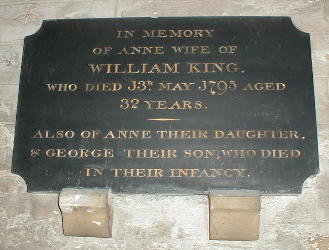
From the Redmile Parish Register
| William King of Belvoir m Anne bur 21.5. 1795 (Age 32) |
Charlotte | bap 4.7.1791 |
| Anne | bap 26.10.1792 bur 23.1.1793 (Infant) | |
| John | bap 17.12.1793 | |
| George | bap 26.3.1795 bur1795 (Infant) | |
| William King and Sarah his wife | Caroline | bap 26.7.1798 |
| William King rm 4.1.1813 Martha Shark |
![]()